솔루션소개
레이저 검측 솔루션 (철도,도로,터널,활주로)
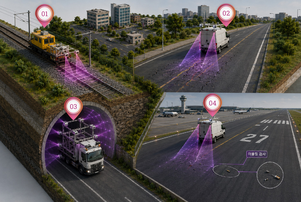
레이저 검측 시스템은 철도,도로,터널,활주로의 상태를 3D 레이저와 영상 기반으로 고속·고정밀 분석하는 자동 검측 솔루션입니다.
주행 중 비접촉 방식으로 균열,변형,마모,이물질 및 구조물 이상 징후를 검출하여 유지보수, 안전진단, 예방정비 및 인프라 자산관리에 활용할 수 있습니다.
The Laser Inspection System is an automated inspection solution that performs high-speed, high-precision analysis of railways, roads, tunnels, and airport runways using 3D laser scanning and imaging technologies.
Operating in a non-contact manner while in motion, the system detects cracks, deformation, wear, foreign objects, and early signs of structural deterioration. The collected data can be utilized for maintenance planning, safety assessments, preventive maintenance, and infrastructure asset management, helping operators improve operational safety and extend asset lifespan.
레이저 레일 검측 시스템(LRAIL)
Laser Rail Inspection System (LRAIL)
레이저 레일 검측 시스템(LRAIL)은 철도 선로와 궤도 구성요소를 고속·비접촉 방식으로 정밀 검측하는 3D 레이저 기반 자동화 솔루션입니다.
차량에 장착된 레이저 센서와 영상 장비를 통해 주행 중 레일, 침목, 체결구, 도상 이음매 등 주요 선로 상태를 연속적으로 스캔하고, 수집된 2D 이미지 및 3D 형상 데이터를 기반으로 이상 여부를 분석합니다. 이를 통해 철도 운영기관은 선로 상태를 객관적으로 확인하고, 예방정비, 유지보수 우선순위 산정, 이상구간 추적 관리 등 데이터 기반의 철도 유지관리 업무를 효율적으로
수행할 수 있습니다.
The Laser Rail Inspection System (LRAIL) is a 3D laser-based automated solution designed for high-speed, non-contact inspection of railway tracks and track components with exceptional accuracy.
Equipped with laser sensors and imaging devices mounted on an inspection vehicle, the system continuously scans critical track elements—including rails, sleepers, fasteners, ballast, and rail joints—while in motion. Using the collected 2D images and 3D geometric data, it automatically analyzes track conditions and identifies potential defects or
abnormalities.
By providing objective and reliable track condition data, LRAIL enables railway operators to efficiently perform data-driven maintenance activities, including preventive maintenance, maintenance prioritization, condition monitoring, and anomaly tracking. This helps improve operational safety, optimize maintenance resources, and enhance the long-term
reliability of railway infrastructure.
핵심 기능 및 시스템
Geometry 5개 항목 검측 가능
- Guage (궤간)
- Cross Level (수평)
- Alignment 10M/30M (방향)
- Longitudinal 10M/30M (고저)
- Twist (뒤틀림)
그외 검측 기능 (옵션)
- 콘크리트 / 나무 침목 크랙(침목 상태) 검사
- 밸러스트 높이 및 오염 검사
- 앵커 채결 여부 검사
- 침목판 및 스파이크 검사
- 레일 마모, 고정장치 체결 여부 검사
신뢰성 검증 (국가공인검증기관 KTR 인증 (재현성/반복성))
- 재현성 및 반복성 신뢰성 검증 완료 (EN13848-1 비교 / 한국화학융합시험연구원)
- 고속검측차(EMOOO) 과 상위 5% 오차에서 모든 측정항목이 측정불확성도 기준을 만족
Key Features & System Capabilities
Geometry Inspection Capabilities
- Guage
- Cross Level
- Alignment 10M/30M
- Longitudinal 10M/30M
- Twist
Additional Inspection Functions (Optional)
- Concrete / wood tie crack (tie condition) inspection
- Ballast level & Fouling
- Anchor inspection
- Tie plates & Spikes
- Elastic fasteners, Rail head profile & wear
Reliability Verification (Certified by KTR, a nationally accredited certification body, for reproducibility and repeatability)
- Verification of reproducibility and repeatability completed (comparison based on EN 13848-1 / Korea Testing & Research Institute)
- All measurement items satisfied the measurement uncertainty criteria within the top 5% error range compared with the high-speed inspection vehicle (EMOOO)
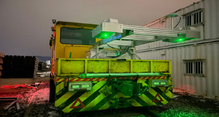
시스템 모터카 장착 (예시)
시스템 우수성
- 고해상도 2D 이미징 및 3D 레이저 프로파일링 결합
- 주/야간 운영 가능
- 인공지능 알고리즘 탑재로 기능의 지속적 개선/보완
- 모터카 탑재시 (40~70Km/h 로 검측수행가능)
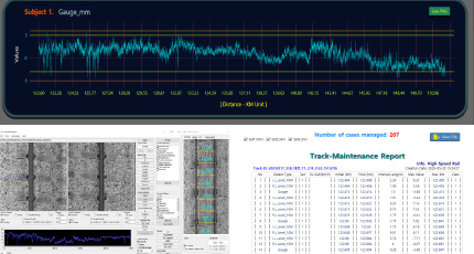
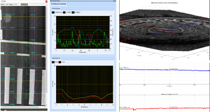
분석 차트 및 분석 보고서 예시 (궤도선형성)
분석 차트 및 분석 보고서 예시 (궤도선형성)
- 다양한 포맷의 리포트 출력물 (PDF, PNG, CSV)
- 검측구간의 보수소요구간 리포트 출력 (PDF,CSV)
- 검측구간의 그래프 차트 출력
- 이상 발생 구간 3D 별도 출력 (이상 원인 식별 가능)
System Installation on Motor car (Example)
System Advantages
- Combination of high-resolution 2D imaging and 3D laser profiling
- Day and night operation capability
- Continuous improvement and enhancement of functions through embedded artificial intelligence algorithms
- When installed on a motor car, inspections can be performed at speeds of 40–70 km/h.
Example Analysis Charts and Analysis Reports (Track Geometry)
Key Deliverables
- Report outputs in various formats (PDF, PNG, CSV)
- Maintenance-required section reports for inspected track segments (PDF, CSV)
- Graph chart outputs for inspected track segments
- Separate 3D outputs for sections where abnormalities are detected (enabling identification of the causes of abnormalities)
레이저 도로 검측 시스템(LCMS)
Laser Road Inspection System (LCMS)
레이저 도로 균열 측정 시스템(LCMS-2)은 포장 도로 검사를 위한 최고의 단일 패스 3D 센서입니다. LCMS-2는 단일 패스에서 포장의 모든 주요 기능 매개변수를 자동으로 위치 정보 태그 지정, 측정, 감지 및 정량화활 수 있습니다. LCMS-2는 인건비와 프로젝트 완료 시간을 크게 줄일 수 있습니다.
완전한 1mm 해상도 자동 포장 상태 조사는 0-100 km/h에서 밤낮으로 완료할 수 있습니다.
LCMS-2 출력에는 XML 형식의 자세한 데이터와 JPEG 형식의 위치 정보 태그가 지정된 포장 도로 이미지가 포함됩니다
The Laser Crack Measurement System (LCMS-2) is the industry's leading single-pass 3D sensor for pavement inspection. The LCMS-2 can automatically geotag, measure, detect, and quantify all major pavement condition parameters in a single pass. The LCMS-2 can significantly reduce labor costs and project completion time. A fully automated pavement condition
survey with 1 mm resolution can be performed day and night at speeds ranging from 0 to 100 km/h.
LCMS-2 outputs include detailed data in XML format and geotagged pavement images in JPEG format.
핵심 기능 및 시스템
주요 기능
- 균열 자동 감지 및 측정 (콘크리트, 아스팔트)
- 포장 유형 감지 (콘크리트, 아스팔트)
- 자동 포트홀 감지 및 측정
- 자동 러팅(Rutting) 측정
- 블리딩(Bleeding) 측정
- 픽아웃(Pick-out) 측정
- 도로 차선 (Lane marking) 감지 및 치수 측정
- 종단면(Longitudinal Profile) 측정 및 거칠기(Roughness) 계산 (옵션)
그 외 검측 기능 (옵션)
- 맨홀 상태 감지 및 분석 기능 (단차, 경사 등)
Key Features & System Capabilities
Key Features
- Automatic crack detection and measurement (concrete, asphalt)
- Pavement type detection (concrete, asphalt)
- Automatic pothole detection and measurement
- Automatic rutting measurement
- Bleeding measurement
- Pick-out measurement
- Road lane marking detection and dimension measurement
- Longitudinal profile measurement and roughness calculation (optional)
Additional Inspection Functions (Optional)
- Manhole condition detection and analysis (level difference, slope, etc.)
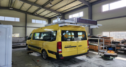
시스템 차량 장착 (예시)
시스템 우수성
- 고해상도 2D 이미징 및 3D 레이저 프로파일링 결합
- 주/야간 운영 가능
- 인공지능 알고리즘 탑재로 콘크리트/아스팔트 균열 검사 가능
- 최대 100km/h 속도에서 1mm 종방향(Longitudinal) 스캐닝
도로 검측 분석 소프트웨어 (맨홀 정밀 분석 기능)
주요 출력물
- 조사분석보고서 출력 (Excel)
- 도로영상 이미지(360 카메라)
- 노면정보, 도로현황정보, 도로포장 분석 결과, 균열 정보 (종류,범위 등)
- 소성변형, 종단평탄성, 기하정보 그래프 출력
System Installation on Vehicle (Example)
System Advantages
- Combination of high-resolution 2D imaging and 3D laser profiling
- Day and night operation capability
- Concrete and asphalt crack inspection through embedded artificial intelligence algorithms
- 1 mm longitudinal scanning at speeds of up to 100 km/h
Road inspection analysis software (manhole precision analysis function)
Key Deliverables
- Survey and analysis report output (Excel)
- Road image output (360° camera)
- Road surface information, road condition information, road pavement analysis results, and crack information (type, extent, etc.)
- Plastic deformation, longitudinal roughness, and geometric information graph outputs
레이저 터널 검측 시스템(LTSS)
Laser Tunnel Inspection System (LTSS)
레이저 터널 검측 시스템(LTSS)은 터널 내부 라이닝과 구조물 상태를 고속·비접촉 방식으로 정밀 검측하는 3D 레이저기반 자동화 솔루션입니다.
차량에 작창된 다중 레이저 스캐너를 통해 주행 중 터널 내벽, 천장부, 측벽 등 전체 단면을 스캔하고, 2D 이미지와 고해상도 3D 형상 데이터를 동시에 취득합니다.
수집된 데이터는 균열, 박리, 변형, 누수 흔적, 단면 변화 등 터널 유지관리에 필요한 주요 정보를 분석하는 데 활용 되며, 반복 검측을 통해 터널 상태 변화를 체계적으로 관리할 수 있습니다.
이를 통해 터널 점검의 안정성, 정확성, 효율성을 높이고, 데이터 기반의 예방정비 및 유지관리 계획을 수립합니다.
The Laser Tunnel Inspection System (LTSS) is a 3D laser-based automated solution designed for high-speed, non-contact inspection of tunnel linings and structural conditions with high precision.
Using multiple laser scanners mounted on a vehicle, the system scans the entire tunnel cross-section, including tunnel walls, ceilings, and sidewalls, while in motion, simultaneously acquiring 2D images and high-resolution 3D geometric data.
The collected data is utilized to analyze key information required for tunnel maintenance, including cracks, spalling, deformation, leakage traces, and cross-sectional changes. Through repeated inspections, changes in tunnel conditions can be systematically monitored and managed.
This enables improved safety, accuracy, and efficiency in tunnel inspections, while supporting data-driven preventive maintenance and maintenance planning.
핵심 기능 및 시스템
주요 기능
- 터널 라이닝, 천장부, 측벽 등 전체 단면 검측
- 1mm 해상도 이미지 및 3D 데이터
- 라이다 스캐닝보다 100배 빠르고 10배 정확도 향상
- 밀리미터 미만의 정확도로 터널 특징 측정
- 최대 50km/h 속도로 스캐닝 가능
- 케이블, 조명기구 및 기타 터널 내 설치된 장치 감지
- 콘크리트 슬래브 정렬 측정
- 균열, 조인트, 단차, 박리, 콘크리트 열화, 누수 흔적 등 결함 탐지
- 터널 단면 형상 및 구조물 변형 상태 분석
- 반복 검측 데이터를 활용한 상태 변화 추적
- 위치정보 기반 검측 데이터 저장 및 이력 관리
- 터널 유지보수 우선순위 선정 및 예방정비 계획 수립 지원
Key Features & System Capabilities
Key Features
- Inspection of the entire tunnel cross-section, including tunnel linings, ceilings, and sidewalls
- 1 mm resolution imaging and 3D data
- 100 times faster than LiDAR scanning and 10 times higher accuracy
- Measurement of tunnel features with sub-millimeter accuracy
- Scanning capability at speeds of up to 50 km/h
- Detection of cables, lighting fixtures, and other devices installed within the tunnel
- Concrete slab alignment measurement
- Detection of defects such as cracks, joints, level differences, spalling, concrete deterioration, and leakage traces
- Analysis of tunnel cross-sectional geometry and structural deformation conditions
- Tracking of condition changes using repeated inspection data
- Storage and history management of inspection data based on location information
- Support for tunnel maintenance prioritization and preventive maintenance planning
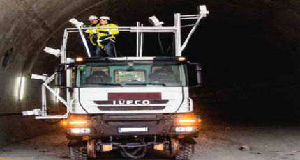
시스템 차량 장착 (예시)
시스템 우수성
- 터널 전체 단면을 고속·비접촉 방식으로 자동 검측
- 밀리미터 수준의 정밀도로 균열, 조인트, 단차, 박리, 열화 누수 흔적 등 결함 분석 가능
- 현장 인력 투입과 교통 통제 시간을 줄여 점검 안전성과 효율성 향상
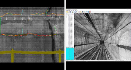
터널 내부 균열 탐지 및 단면 형상 분석
주요 출력물
- 터널 라이닝 2D 고해상도 이미지
- 터널 내부 3D 프로파일 및 단면 형상 데이터
- 균열, 박리, 누수 등 결함 검출 결과
- 결함 유형별 위치, 길이, 면적, 심도 등 정량 분석 데이터
System Installation on Vehicle (Example)
System Advantages
- Automated inspection of the entire tunnel cross-section using a high-speed, non-contact method
- Defect analysis of cracks, joints, level differences, spalling, deterioration, and leakage traces with millimeter-level precision
- Improved inspection safety and efficiency by reducing field personnel requirements and traffic control time
Tunnel internal crack detection and cross-sectional geometry analysis
Key Deliverables
- High-resolution 2D images of tunnel linings
- 3D profiles and cross-sectional geometry data of tunnel interiors
- Defect detection results for cracks, spalling, leakage, and other defects
- Quantitative analysis data including location, length, area, and depth by defect type
레이저 활주로 검측 시스템(LFOD)
Laser Runway Inspection System (LFOD)
레이저 활주로 검측 시스템(LFOD)은 공항 활주로, 유도로, 계류장 표면의 이물질(FOD)과 노면 상태를 고속·비접촉 방식으로 검사하는 레이저 기반 자동화 솔루션입니다.
차량에 장착된 고속 카메라, 레이저 라인 프로젝터, 정밀 광학 장비를 통해 주행 중 2D 영상과 고해상도 3D 형상 데이터를 동시에 취득하며, 작은 이물질까지 자동으로 탐지할 수 있습니다.
또한, 주야간 및 다양한 조명 환경에서도 안정적인 검측이 가능하여 공항 운영 중 활주로 안전점검, FOD 관리, 예방정비, 유지관리 업무의 효율성을 향상시킵니다.
The Laser Runway Inspection System (LFOD) is a laser-based automated solution that inspects foreign object debris (FOD) and pavement conditions on airport runways, taxiways, and aprons using a high-speed, non-contact method. Using high-speed cameras, laser line projectors, and precision optical equipment mounted on a vehicle, the system simultaneously
acquires 2D images and high-resolution 3D geometric data while in motion, enabling the automatic detection of even small foreign objects.
In addition, stable inspection is possible during both day and night and under various lighting conditions, improving the efficiency of runway safety inspections, FOD management, preventive maintenance, and maintenance operations during airport operations.
핵심 기능 및 시스템
주요 기능
- 5mm 만큼 작은 FOD도 감지 가능
- 주/야간 운영 가능 (*조명의 영향을 받지 않음)
- 특정 FOD 크기에 대한 차량 내 실시간 알림
- 재검측 없이도 다른 파라미터를 이용해 데이터 재처리 가능
- 고정식 지상 기반 시스템에 비해 탁월한 가격 경쟁력
- 사용자가 구성할 수 있는 알림 및 심각도
- 라이브 맵 인터페이스를 통해 잠재적인 FOD를 쉽게 검색 가능
- FOD의 정확한 GPS 태깅, <10cm GPS 정확도
- GIS 매핑이나 자산 관리 시스템을 위해 Excel로 쉽게 변환 가능
- 아스팔트 / 콘크리트 활주로 크랙검사 병행 (크랙은 향후 FOD로 전환되기 때문에 예방차원에서 집중관리 필요)
- 검측 작업영역(Path) 모니터링 기능 제공
- 자동 FOD 탐지
Key Features & System Capabilities
Key Features
- Capable of detecting FOD as small as 5 mm
- Day and night operation capability (*not affected by lighting conditions)
- Real-time in-vehicle alerts for specific FOD sizes
- Data can be reprocessed using different parameters without reinspection
- Superior cost competitiveness compared to fixed ground-based systems
- User-configurable alerts and severity levels
- Easy identification of potential FOD through a live map interface
- Accurate GPS tagging of FOD, with GPS accuracy of <10 cm
- Easily convertible to Excel for GIS mapping or asset management systems
- Simultaneous crack inspection of asphalt and concrete runways (as cracks may develop into FOD in the future, focused preventive management is required)
- Monitoring function for inspection work areas (Path)
- Automatic FOD detection
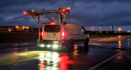
시스템 차량 장착 (예시)
시스템 우수성
- 고해상도 2D 이미징 및 3D 레이저 프로파일링 결합
- 주/야간 운영 가능
- 5mm만큼 작은 FOD도 감지 가능
- 특정 FOD 크기에 대한 차량 내 실시간 알림
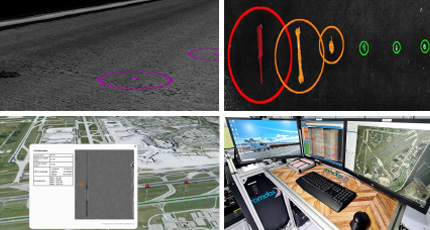
FOD 탐지 및 GIS 매핑 프로그램
주요 출력물
- FOD의 위치 및 크기 탐지
- 균열, 박리, 거친 표면 상태, 콘크리트 조인트, 포트홀 등
- 포장 상태 분석
- 지오태그(Geotagged)가 포함된 포장 이미지(JPEG)
System Installation on Vehicle (Example)
System Advantages
- Combination of high-resolution 2D imaging and 3D laser profiling
- Day and night operation capability
- Capable of detecting FOD as small as 5 mm
- Real-time in-vehicle alerts for specific FOD sizes
FOD detection and GIS mapping program
Key Deliverables
- Detection of FOD location and size
- Cracks, spalling, rough surface conditions, concrete joints, potholes, etc.
- Pavement condition analysis
- Geotagged pavement images (JPEG)