제품소개
Pavemetrics (캐나다) Rail Inspection System (레이저 선로검사 시스템)
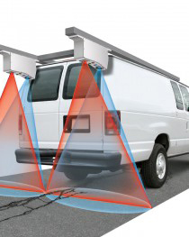
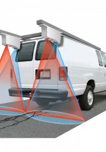
Pavemetrics® 레이저 레일 검사 시스템(LRAIL™)은 선로를 검사하기 위한 완전히 새롭고 효율적인 비용의 방법을 제공합니다.
현재 대부분의 레일 검사 센서는 단일 기능으로 제한됩니다. 게이지와 같은 특정 매개변수를 측정하거나 이미징 또는 tie grading과 같은 단일 작업을 수행합니다.
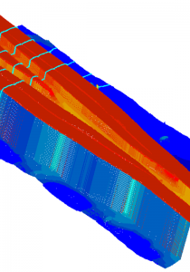
LRAIL™은 인공 지능을 사용하여 완전 자동화된 분석을 통해 2D 이미지 및 3D 스캐닝을 제공하는 다기능 검사를 제공함으로써 더 큰 ROI를 제공합니다.
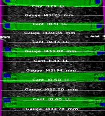
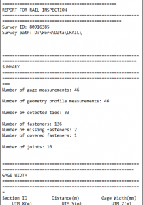
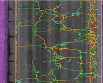
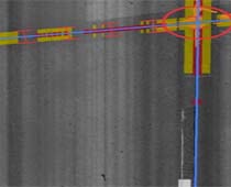
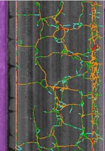
LRAIL™의 인공 지능 알고리즘은 아래의 항목에 관련된 변화를 자동으로 측정하고 감지합니다.
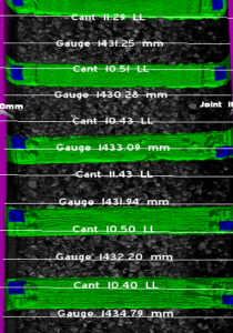
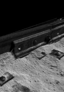
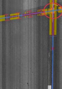
(Gauge, Cross level, Alignment, Spikes, Clips, Tie plates, Joint gap, Joint bar bolting, Rail surface wear and tie grade)

Key Features
- Inspection at speeds up to 120 km/h
- Supports narrow, standard and wide gauge measurements
- Simultaneous 3D point cloud and and 2D high-resolution Imaging
- Daytime and night-time operation, immunity to shadows
-
Fully automated Artificial Intelligence-based railway inspection:
- Change detection
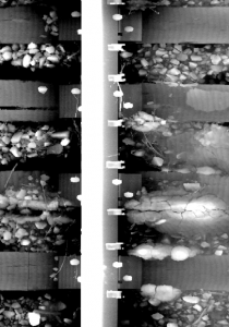
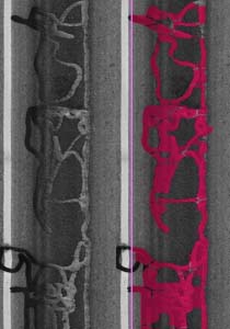
- Wooden tie grading (location, skew angle, crack length, crack depth, crack width, tie grade)
- Concrete tie grading (location, skew angle, crack length, crack depth, crack width, tie grade)
- Clip inspection (location, type, loose, missing, damaged, covered)
- Crossing inspection (location, crossing point detection, wear profiles)
- Switch inspection (location, toe detection, toe damage, foot detection)
- Rail open surface damage (chips, cracks)
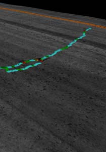
- Joint detection and gap measurement
- Joint bar bolt counting
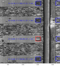
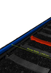
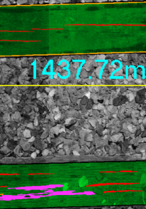
- Gauge width, cross-level between rails, alignment
- Railhead top and side wear (also grooved rail wear)
- Data are automatically location-referenced using mile-point and inertially corrected GPS (x, y and z)
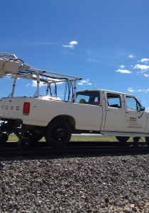
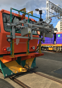
- Compact; sensors weigh only 13 kg each and can be mounted on a high-rail vehicle or a dedicated inspection car
- Rugged components mounted in environmentally-sealed enclosures
- Low-power consumption
- Data compression algorithms to minimize storage requirements
Specification
- 28,000 Hz scanning frequnecy
- 60 km/h at 1mm intervals, 120 Km/h at 2mm intervals
- 1 mm transverse resolution
- 0.1 mm vertical resolution
- 0.25 mm vertical accuracy
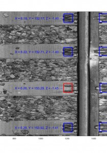
Rail Inspection System 적용 사례
Rail Inspection System 기술 영상
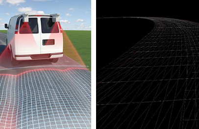
Pavemetrics (캐나다) Road Inspection System (레이저 도로검사 시스템)
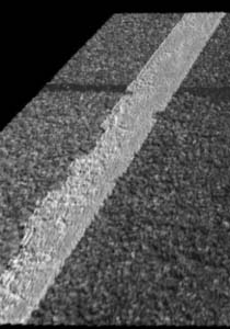
Pavemetrics® 레이저 균열 측정 시스템(LCMS-2)은 포장 도로 검사를 위한 최고의 단일 패스 3D 센서입니다. LCMS-2는 단일 패스에서 포장의 모든 주요 기능 매개변수를 자동으로 위치 정보 태그 지정, 측정, 감지 및 정량화할 수 있습니다.
LCMS-2는 인건비와 프로젝트 완료 시간을 크게 줄일 수 있습니다. 완전한 1mm 해상도 자동 포장 상태 조사는 0-100+km/h에서 밤낮으로 완료할 수 있습니다.
LCMS-2 출력에는 XML 형식의 자세한 조난 데이터와 JPEG 형식의 위치 정보 태그가 지정된 포장 도로 이미지가 포함됩니다.
Key Features
- Automatic detection and measurement of cracking (both sealed and unsealed)
- Automatic rutting measurement (compliant with ASTM E1703, Taut Wire, Moving Ruler, Brazilian method, 5 Point rut depth calculation)
- Automatic pothole detection and measurement
- Automatic detection and measurement of raveling (an industry first)
- Automatic measurement of macro-texture (MPD, MTD) in all 5 AASHTO bands
- Pick-out detection
- Bleeding detection and measurement
- Delamination detection and measurement
- Shoving detection and measurement
- Sewer and storm-drain detection and inventory
- Rumble strip detection and inventory
- Water-entrapment calculation
- Edge drop off and curb detection and measurement
- Joint detection and faulting measurement
- Pavement type detection (asphalt and concrete)
- Pavement marking detection and dimension measurement
- GPS tagging of measurements and images (using Customer-supplied GPS)
- Measurement of longitudinal profile and calculation of roughness (optional)
- Slope, Cross Fall and Super Elevation (optional)
Specification
- 28,000 Hz scanning frequnecy
- 1 mm longitudinal scanning interval at speeds up to 100 km/h
- 1 mm transverse resolution
- 0.25 mm vertical accuracy
- 0.05 mm vertical resolution for IRI measurements at 25mm (1 inch) intervals (confidence level of 95%)
Road Inspection System 적용 사례
Road Inspection System 기술 영상
Pavemetrics (캐나다) Tunnel Inspection System (레이저 터널검사 시스템)
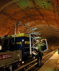
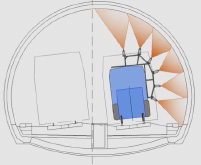
Pavemetrics® 레이저 터널 스캐닝 시스템(LTSS)은 여러 개의 고속 레이저 스캐너를 사용하여 터널 라이닝의 2D 이미지와 고해상도 3D 프로파일을 모두 획득합니다.
LTSS는 일반적인 LIDAR 기술보다 100배 빠르고 10배 더 정확합니다. 1mm 이미지 해상도로 12m 터널 볼트를 스캔하고 최대 20km/h의 수집속도로 3D 데이터를 스캔할 수 있습니다.
디지털화되면 거의 모든 터널 기능을 고정밀 측정할 수 있는 다중 해상도 3D 보기 및 분석 소프트웨어를 사용하여 운영자가 터널 데이터를 오프라인에서 보고 분석 할 수 있습니다.
또한, 자동 분석 소프트웨어를 사용하여 조인트, 결함, 균열 및 열화된 콘크리트의 상태와 터널 라이닝의 침수 지점을 감지하고 평가할 수 있습니다.
Key Features
- Full-vault scanning
- 1-mm-resolution images and 3D data
- 100 times faster and 10 times more accurate than LIDAR scanning
- Measurement of tunnel features with sub-millimeter accuracy
- Visualization of 1-mm surface defects from any point of view without leaving the office
- Scanning speeds of up to 20km/h
- Automatic analysis software of voussoir-type tunnels available
- Rail scanning option available
Specification
- 30,000 Hz scanning frequency
- 1 mm longitudinal scanning interval at speeds up to 110 km/h or 2 mm longitudinal scanning interval at 200+ km/h
- 1 mm transverse resolution
- 0.5 mm vertical accuracy
Tunnel Inspection System 기술 영상
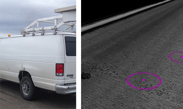
Pavemetrics (캐나다) Airfield Inspection System (레이저 비행장 검사 시스템)
Pavemetrics® LFOD(Laser Foreign Object Debris) 감지 시스템은 고속 카메라, 맞춤형 광학 장치 및 레이저 라인 프로젝터를 사용하여 가장 작은 물체도 자동으로 감지하기 위해 공항 활주로, 유도로의 2D 이미지와 고해상도 3D 프로파일을 모두 획득합니다.
LFOD 시스템은 주간 및 야간뿐만 아니라 모든 유형의 조명 조건에서 작동할 수 있습니다. 어두운 아스팔트에서 콘크리트에 이르는 다양한 포장 유형뿐만 아니라 태양이 비추거나 그림자로 덮인 표면을 0 ~ 100km/h의 검사 속도로 스캔할 수 있습니다.
Key Features
- Detection of FOD as small as 2mm
- 24-hour operation; daytime and night-time
- Automated detection; alarms can be pre-set to trigger upon detection of specific FOD sizes
- Safe and efficient; operational speeds from 0 to 100km/h
- Flexible configuration; scanning width of 12 to 18m per pass
- Cost-effective installation; typically can be mounted on existing inspection equipment
- Accurate; GPS tagging of detected debris
- Can be used in conjunction with GPS display for visual guidance
Specification
- Exceeds FAA AC 150/5220-24 guidelines for detection of debris that are 5cm or larger
- Exceeds FAA AC 150/5220-24 guidelines for debris location determination accuracy (5m)
- Exceeds FAA AC 150/5220-24 guidelines for FOD detection alarm, reporting and mapping
Airfield Inspection System 기술 영상
Pavemetrics (캐나다) Digital Terrain Mapping (레이저 디지털 지형 매핑 시스템)
Pavemetrics® LDTM(Laser Digital Terrain Mapping System)을 사용하면 전례없는 정확도와 해상도로 도로 표면을 3D로 매핑할 수 있습니다.
LDTM 시스템은 레이저 라인 프로젝터, 고속 카메라 및 고급 광학 장치를 사용하여 도로의 고해상도 3D 프로파일을 획득합니다. 이 고유한 3D 비전 기술은 GPS 및 관성 측정 장치(IMU)와 통합되어 차량 위치를 정확하게 추적하고 차량 움직임의 효과에 대한 3D스캔을 수정합니다.
LDTM은 최대 100km/h의 측량 속도에서 4m 차선 폭에 대해 1mm 해상도로 노면 데이터를 수집합니다. 2D 이미지와 3D 데이터는 모두 초당 최대 4,500만 포인트의 속도로 동시에 수집되며 고정밀 디지털 지형 지도로 원활하게 병합됩니다.
Key Features
- Automatic generation of breaklines
- Detection of road edges, lane markings, curbs
- Day and night operation
- Low power consumption
- High resolution (1 mm) downward images
- Slope, curvature and crossfall
Specification
- Millimeter accuracy digital terrain models
- 45 MHz point generation
- 1 mm longitudinal scanning interval
- 1 mm transverse resolution