제품소개
Romdas
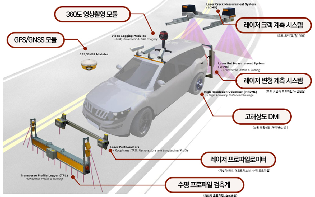
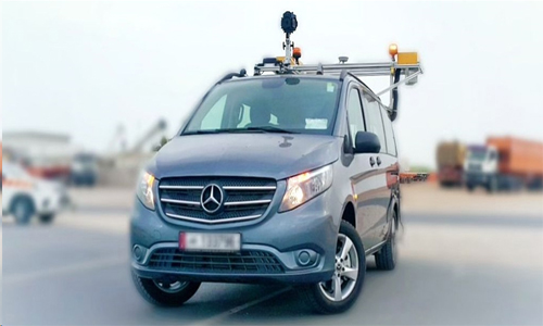
Romdas (뉴질랜드) 실시간 활주로 FOD 검측 및 크랙 분석 시스템
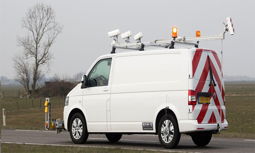
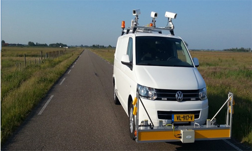
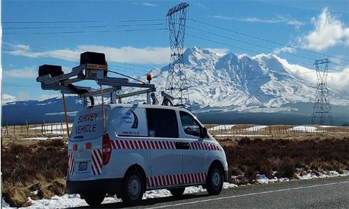
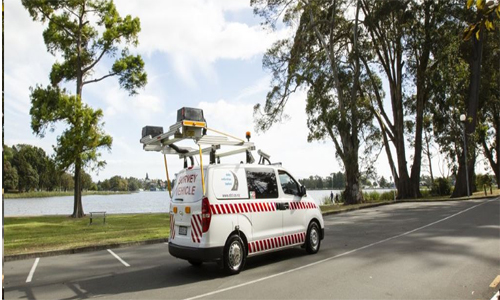
ROMDAS는 현지에서 조달한 도로 측량 차량을 이용하여 자산 및 포장 정보를 수집하기 위해 개발된 모듈식 시스템입니다. ROMDAS의 설계는 민간 컨설턴트, 정부부처, 연구기관에 상관없이 다양한 포장 데이터를 신속하게 정확하게 측정할 수 있도록 뛰어난 유연성과 사용 편의성을 제공하기 위해 기술과 함께 발전했습니다. Central ROMDAS 시스템은 측량 데이터를 수집하기 위한 핵심 하드웨어 구성 요소, 주행 기록계, 인터페이스 및 소프트웨어 라이센스를 포함합니다. 추가 데이터 세트를 기록하기 위해 이 Central 시스템에 모듈을 추가할 수 있으며, 거의 모든 차량에 설치할 수 있습니다. 이 시스템은 사용자가 필요하지 않은 구성 요소에 예산을 쓰지 않고도 프로젝트의 요구에 맞는 모듈에 맞게 조정할 수 있도록 설계되었습니다
Romdas 시스템
Video
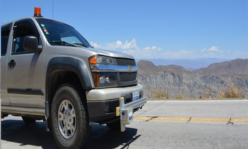
Laser Profilometer
ROMDAS 레이저 프로파일러 모듈은 Class I 관성 프로파일러이며 ASTM E950을 준수합니다. 고속에서도 고도의 정확성을 위해 레이저와 가속도계의 조합을 사용하여 도로의 종방향 고도 프로파일을 측정하며 프로파일을 분석하여 도로 표면에 대한 국제 조도 지수(IRI) 값을 계산합니다
Key Features & Features
- World Bank Class 1 Profiler
- Meets ASTM E950 standard
- 3 Axis accelerometer
- Highly competitive pricing
- Extremely Portable weighing around 3kgs
- Single or dual laser systems available for measuring one or two wheel paths
- Easily customised to include other modules such as GPS, Geometry, Video Logging, Transverse Profile Logger, LCMS
Data Output
- Distance/Chainage
- Roughness (IRI)
- Raw Longitudinal Profile (Compatible with industry standard software like ProVal)
- Macro-texture (MPD) Upgrade available
- ROMDAS Lasers can be upgraded to measure macro-texture in terms of Mean Profile Depth (MPD). The MPD texture upgrade replaces the standard laser unit with a higher speed laser.
- Additional Lasers
- Additional lasers can be purchased separately to give multiple road profiles
Laser Crack Measurement System
ROMDAS LCMS는 자동화된 도로 상태 조사를 위해 Pavemetrics의 최신 레이저 스캐닝 기술을 사용합니다. LCMS는 자동화된 도로 상태 조사를 위해 높은 정확도의 3D 도로 표면 프로파일을 수집합니다. 이러한 3D 프로파일은 업계 표준 알고리즘을 사용하여 분석되어 다양한 중요한 데이터 세트를 계산합니다. 자동화된 도로 균열 감지 및 분류와 함께 이 스캐닝 레이저 장치는 포트홀, 패치, 러팅, 매크로 텍스처(MPD), 라벨링, 조인트/폴팅 등을 측정합니다.
Key Features & Features
- Exceptional price for a system utilizing Pavemetrics™ LCMS lasers
- Pavement images with cracking and defects automatically overlaid
- 4m width profiles with +4,000 points per profile
- Detects cracks down to 1mm
- Operates up to 100km/h
- Lane tracking feature for consistency
- Day or night operation
- Upgrade for airport FOD detection available*
- Add ROW cameras, GPS and other modules to supplement LCMS™ data
- Real-time display during surveying
- Non-proprietary data formats and easily exportable to Excel, GIS mapping or asset management systems
- Reprocess data using different parameters without re-surveying
- Roof mounted, not bumper mounted, for increased mobility
- System powered by vehicle battery, no need for additional generators
Data Output
- Cracking (Longitudinal, transverse, alligator, multiple, sealed cracks)
- Potholes
- Rut depth, width & cross-sectional area for each wheel path
- Macro-texture (MPD) across whole lane width in 5 AASHTO band
- Bleeding
- Raveling
- Shoving
- Concrete joint/faulting
- Water pooling
- Lane Marking
- Pumping
- Patching
- Water entrapment
- Geotagged Pavement images (.JPEG)
- Longitudinal profile/Roughness (IRI in both wheel paths)*Optional Upgrade
- Geometry (slope, cross-fall, radius of curvature, super elevation)*Optional Upgrade
Laser Foreign Object Detection (LFOD)
차량에 장착된 ROMDAS LFOD 시스템은 첨단 3D 레이저 스캐닝 기술과 서브미터 GPS를 사용하여 비행장 전체에 FOD를 자동으로 감지하고, 실시간으로 경고하고, 보관합니다. 이 시스템은 거의 모든 재료와 색상의 FOD를 쉽게 감지하며, 자동으로 GIS 지도를 생성하여 FOD 관리 및 예방을 위해 가능한 핫스팟을 식별합니다. 또한 효과적인 비행장 관리에 유용한 다양한 포장 상태 데이터를 수집합니다.
Key Features & Features
- Rapid and flexible operations with mobile LFOD system
- Exceptional price compared to stationary ground-based systems
- No airside construction, roof mounted for increased mobility
- Scanning width of 5m per pass
- Detects FOD as small as 5mm
- Real-time alerts in vehicle for specific FOD sizes
- User configurable alerts and severities
- Live map interface allows easy “find and retrieve” of potential FOD
- Operate in day or night conditions
- Operating speed 0-100km/h
- Accurate GPS tagging of FODs, >10cm GPS accuracy (when connected to RTX signal)
- Non-proprietary data formats; easy conversion to Excel, for GIS mapping or asset management systems
- Reprocess data using different parameters without re-surveying
- Add cameras and other modules to supplement LFOD data
- Meets all recommended FAA FOD inspection areas: runways, taxiways, aprons, aircraft servicing operations, air cargo operations, construction, aircraft maintenance activities (FAA AC: 150-5210-24)
Data Output
- FOD detection with location and dimensions
- Pavement condition such as cracking, ravelling, macrotexture, concrete joints, potholes etc.
- Geotagged Pavement images (.JPEG)
Optional Upgrades
- Longitudinal profile/Roughness (IRI and BBI in both wheel paths)
- Geometry (slope, cross-fall, radius of curvature, super elevation)
- LDTM Terrain Mapping .LAS files for CAD
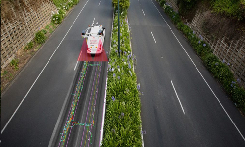
Right of Way Video & Mobile Mapping
ROMDAS Right of Way Video Logging 모듈은 ROW(Right of Way)의 시각적 기록을 생성하여 도로 자산 및 재고에 대한 정보를 수집하는 데 사용됩니다. 고해상도 단일 ROW 카메라 또는 360 뷰 카메라 중에서 선택할 수 있습니다. 단일 ROW 카메라의 수는 프로젝트 요구 사항에 맞게 사용자 지정하고 원하는 방향으로 조정할 수 있습니다. ROMDAS Right of Way Video Logging 모듈은 도로 이미지를 수집하고 직접 디지털화하여 표준 JPEG 또는 AVI 형식으로 출력합니다. 이러한 이미지는 WMP, Quicktime, VLC, MPC 등과 같은 가장 일반적으로 사용되는 미디어 플레이어에서 쉽게 볼 수 있습니다. 사용자는 해상도를 정의하고 사용자 정의할 수 있으며 이미지는 사용자 정의된 간격으로 측량 컴퓨터에 기록되고 저장되어 파일 크기를 줄일 수 있습니다(예: 매 5m 또는 10m). 측량을 수행하면 도로 이미지를 실시간으로 볼 수 있어 수집된 데이터의 품질과 측면을 지속적으로 모니터링할 수 있습니다.
Key Features & Features
- Customizable image overlay referencing location and survey information
- User-defined trigger distance for reduced files sizes
- Real-time status display for immediate feedback on correct operation of the system
- Custom camera configurations available
- High resolutions images
- Roof mounted cameras offering better scope of view than dashboard mounted camera systems
- Additional cameras can be added to increase the range and scope of road asset or condition surveys
Data Output
- Right Of Way Video Logging
- GIS maps extracted from survey imagery
- Standard .JPEG or .AVI image format
Pavement View Video
ROMDAS 포장도로 보기 비디오 기록 모듈은 시각적 상태 평가를 위해 포장도로 표면의 기록을 만듭니다. 차량 후면에 수직으로 장착된 단일 카메라는 차선의 폭을 충분히 커버하고 도로 이미지를 실시간으로 볼 수 있습니다. 이러한 이미지는 사무실의 안전으로부터 가장 일반적인 결함을 감지하고 측정하는 데 도움이 될 것입니다. ROMDAS 포장 보기 비디오 기록 모듈은 노면 영상을 수집하여 사용자가 정의한 간격으로 측량 컴퓨터에 직접 저장합니다. ROMDAS 소프트웨어는 가장 일반적으로 사용되는 미디어 플레이어에서 쉽게 볼 수 있도록 표준 JPEG 또는 AVI 형식으로 영상을 디지털화합니다. 수집된 영상은 결함 탐지 및 분석을 위해 DataView 후처리 소프트웨어에서 볼 수 있습니다.
Key Features & Features
- Customizable image overlay referencing location and survey information
- User-defined trigger distance for reduced files sizes
- Real-time status display for immediate feedback on correct operation of the system.
- High resolutions images
- Roof mounted camera positioned at the rear of the vehicle facing the road surface for better viewing angle
Data Output
- Pavement Video Logging
- GIS maps extracted from survey imagery
- Standard .JPEG or .AVI image format
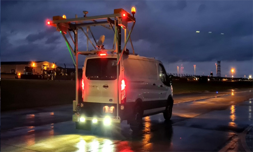
Transverse Profile Logger
ROMDAS는 15개의 단일 포인트 레이저 센서가 장착된 고품질 레이저 기반 횡단 프로파일 로거(TPL)를 제공하여 차선을 가로질러 업계 표준 횡단 프로파일을 출력합니다. 해당 횡단 프로파일을 분석하여 표면 러팅의 정도를 계산합니다. 이 장치는 차량 전면에 장착되어 보관을 위해 쉽게 제거할 수 있습니다. 대부분의 레이저 기반 Rut Bar 장치에 비해 ROMDAS TPL은 더 많은 수의 접촉점을 제공하여 더 적은 접촉점을 가진 레이저 기반 장치와 마찬가지로 고품질의 횡방향 프로파일을 제공합니다. 이 ASTM 호환 TPL은 레이저 기반 장비에 특징지어지는 매우 견고하고 경 제적인 향상된 정확도를 제공합니다.
Key Features & Features
- One of the best combinations of cost efficiency and high accuracy on the market.
- Robust for use in the toughest conditions.
- Easily installed and removable when not in use.
- Operating speed from 0-100km/h
- User defined sampling and report intervals.
- Requires little-to-no operator input during surveying.
Data Output
- Transverse profile
- Rut depth measurments (using theoretical 2m straight edge method)
Bump Integrator
범프 인테그레이터(BI)는 비포장 도로의 조도 조사에 사용되는 Class 3 응답형 도로 조도 측정 장비입니다. 지난 수십 년 동안 BI는 다양한 기후와 도로 조건을 가진 국가에서 널리 구현되었습니다. 조도를 측정하고 IRI를 계산하는 데 저렴한 옵션입니다. BI· 장치는 레이저 기반 프로파일링 장비를 사용할 수 없는 거칠고 비포장이거나 습한 조건에서 탁월합니다. 범프 인테그레이터가 있는 ROMDAS 시스템은 작업자 상호 작용이 거의 또는 전혀 필요하지 않으며 모든 판독값이 실시간으로 측량 컴퓨터에 표시됩니다. BI의 원시 조도 데이터는 ROMDAS System과 함께 설치된 노트북에 직접 기록됩니다. 잘 보정된 BI는 일부 가속도계 기 반 장비를 포함하여 다른 Class 3 조도 프로파일러의 정확도와 쉽게 필적하거나 능가합니다.
Key Features & Features
- High resolution, high reliability optical encoder
- Designed for use in some of the most extreme and rugged road conditions
- Low minimum operating speed (10km/h)
- Very low cost compared to vehicle mounted accelerometer-based equipment
- Simple design allows for quick and easy installation and full serviceability in the fiel
Data Output
- Longitudinal Profiles
- Roughness (IRI)
GPS Receivers and Geometry
GPS 좌표로 동시에 수집된 모든 ROMDAS 측량 데이터를 지오 레퍼런싱합니다. 시스템은 또한 GPS 데이터를 사용하여 차량 또는 도로 중심선의 위치를 설정할 수 있습니다. 지오레퍼런스 데이터는 GIS 매핑 또는 자산 관리 소프트웨어와 쉽게 통합할 수 있습니다. 실시간 서브미터 정확도에서 최대 5cm GPS 정확도를 위해 RTK(Real-Time Kinetic) 기지국에 이르기까지 ROMDAS 시스템은 특정 정확도 요구 및 예산에 맞게 다양한 GNSS 구성과 연결할 수 있습니다.
Key Features & Features
- Light weight and easy to install
- No operator input required during surveys
- High update rate of 100Hz
- GPS Coordinates imprinted on all data collected by ROMDAS modules
- Fill-in GPS coordinates during GPS drop-outs (Dead Reckoning)
- Efficient and economical option for collecting network level geometry data
- Essential for Mobile Mapping
Data Output
- GPS Coordinates
- Geometry outputs: Cross-slope, gradient (%), radius of curvature (m)
High Resolution Distance Measuring Instrument
고해상도 거리 측정 기기(HR-DMI)는 매우 정확한(> 0.1m) 거리 측정이 필요한 프로젝트에 사용됩니다. 강력한 인코더는 애플리케이션에 따라 회전당 360에서 10,000 펄스까지 프로그래밍할 수 있습니다. HRDMI는 LCMS, Transverse Profile Logger 또는 Laser Profilometer와 같은 레이저 기반 장비를 사용하는 모든 ROMDAS 시스템의 요구 사항입니다.
Key Features & Features
- Light weight and easy to install
- No operator input required during surveys
- High update rate of 100Hz
- GPS Coordinates imprinted on all data collected by ROMDAS modules
- Fill-in GPS coordinates during GPS drop-outs (Dead Reckoning)
- Efficient and economical option for collecting network level geometry data
- Essential for Mobile Mapping
Data Output
- High Resolution Distance/Chainage.
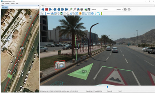
ROMDAS Office Post-Processing Software
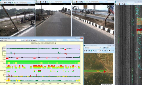
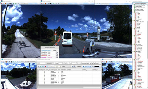
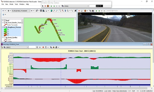
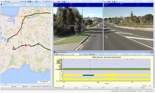
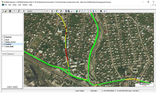
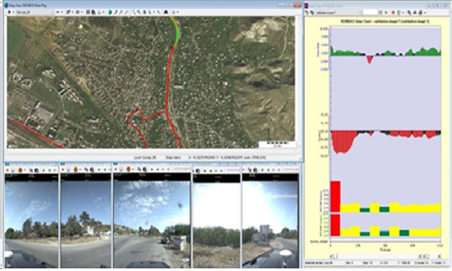
고급 데이터 통합 및 후처리 소프트웨어인 DataView는 ROMDAS 장비 사용자를 위한 다용도 도구입니다. 도로 데이터를 관리하고 처리하는 엔지니어와 측량 관리자는 특히 수치 정보를 시각적 보고서로 제시하는 데 이점을 활용할 수 있습니다. DataView는 개별 측량 파일을 하나의 중앙 데이터베이스로 통합합니다. 사용자 정의 그래프, 차트 및 지도에 데이터를 표시하는 데 도움이 됩니다. 모든 데이터는 체인지(거리) 정보 및/또는 GPS 위치를 사용하여 연결됩니다. 이 연결은 그래프 데이터, GIS 지도 및 디지털 비디오 이미지 사이를 추적하는 데 도움이 됩니다. DataView 소프트웨어는 사용자가 연결된 비디오, GIS 지도 및 스트립 지도를 동시에 볼 수 있고 품질과 정확성을 위해 데이터를 확인할 수 있는 필수 QA (Quality Assurance) 도구입니다. 후처리 소프트웨어는 원시 GPS 참조 데이터를 ArcGIS, Google Earth 또는 다른 제 3자 소프트웨어와 같은 GIS 매핑 소프트웨어로 쉽게 내보낼 수 있는 GIS 지도 계층으로 변환할 수 있습니다.
Key Features & Features
- Light weight and easy to install
- No operator input required during surveys
- High update rate of 100Hz
- GPS Coordinates imprinted on all data collected by ROMDAS modules
- Fill-in GPS coordinates during GPS drop-outs (Dead Reckoning)
- Efficient and economical option for collecting network level geometry data
- Essential for Mobile Mapping
Data Output
- High Resolution Distance/Chainage.
Video Rating
Quality Control
Data Presentation
GIS Mapping
Presentation Licenses
Mobile Mapping